Do You Know...???
Updated 08/24/2023

|
Do You Know...??? is our webpage in which we place our deepest, darkest secrets to be unraveled. These secrets are sooo deep, sooo dark that even we don't know what they are! Basically, each "secret" is a "Mystery of History"...something that we need help in identifying or researching. This page will post unsubstantiated historical rumors, photographs which need identifying, topics in which we need some assistance in properly researching, etc. If you have any knowledge about the mystery, know someone who might be knowledgeable about the mystery, or have a suggestion on how to best proceed in researching the mystery, please contact us with that information in order that we might continue to preserve the history of the Auburn area. Thanks!
|
Mystery Listing by Number & Title (still unsolved):
003 - "The Secluded Cemetery" (Do you know anything about a cemetery behind Stein's Beagle Club?)
004 - "The Enigmatic Enterprise" (Do you know anything about this early Market Street restaurant?)
005 - "The Praying Church" (Do you know anything about this Washington Street church or congregation?)
006 - "The Healing Church" (Do you know anything about this Orchard Street church or congregation?)
009 - "Those Taxing Textiles..." (Do you know anything about the location of these textile factories?)
011 - "The Baffling Brothel" (Do you know anything about the "Sugar Shack" outside of Auburn?)
012 - "The Stumping Structure" (Do you know anything about this missing building in Auburn?)
015 - "The Heavenly Recruits" (Do you know anything about this congregation of worshipers?)
017 - "The (Original?) Auburn Shirt Factory" (Do you know anything about this mystery structure?)
018 - "The Stymieing Store" (Do you know anything about this early retail establishment?)
019 - "The Distant Dairy" (Do you know anything about this dairy operation?)
Mystery Listing by Number & Title (partially/totally solved):
001 - "The Frustrating Furnace" (Do you know anything about Haywood's Furnace south of Auburn?)
002 - "The Baffling Bridge" (Do you know anything about a small bridge near the Schuylkill River?)
007 - "The Reclusive Road" (Do you know anything about an early "Railroad Street" in Auburn?)
008 - "The Man of Mystery" (Do you know anything about after whom "Deiter Snyder Street" was named?)
010 - "The Sacrosanct Cemetery" (Do you know anything about the Mill Street cemetery's ownership?)
013 - "The Chiseled Church" (Do you know anything about this unknown/unidentified church?)
014 - "The Movie Star Mystery" (Do you know anything about a business called "Movie-Star, Inc.?)
016 - "The Grave-digging Hermit" (Do you know anything about this somewhat reclusive individual?)
"MYSTERIES OF HISTORY"
**************************************************************
|
Mystery #001 - "The Frustrating Furnace"
(see below in "What We DO Know...") |
**************************************************************
|
Mystery #002 - "The Baffling Bridge"
(see below in "What We DO Know...") |
**************************************************************
|
Mystery #003 - "The Secluded Cemetery"
The picture on the right, taken in 1950, features the building later used for the Stein's Hollow Beagle Club located south of Auburn. As is evident, the building was already abandoned as an old structure in 1950. The question is: Did the original occupants of this house have knowledge of a burial ground located on the ridge behind their home? A now deceased source had stated that a cemetery was once located on the ridge "behind" the Auburn Beagle Club. This comment was made in passing and was, unfortunately, not expanded upon at that time. As a result, we do not know if the source had personal and definitive knowledge of its existence or whether their statement was based on hearsay. Presently, no record of this cemetery seems to exist in either official documentation or map references. All of the individuals who have been questioned about the cemetery, many of whom are local residents who have hunted or walked this ridge for decades, have any recollection of a burial ground in this area. The mystery might have ended there except for the "note". A rather cryptic note by an unknown author was found in a a pile of old documents which had been donated years earlier to the Auburn Area Historical Society. The donor of this note is unknown. This note alludes to a "burial ground" located "Behind the barns at the Beagle Club". The note implies the site may have existed "before the S. (Summer) Hill Church Barn" and that it was a "Church burial ground". A question on the note even ponders whether the burial ground may have belonged to the "Ref. (Reformed) Church". So...there exists two possibly separate references to this mysterious "burial ground". Was this an early church burial ground...possibly from when religious congregants were still meeting in private residences before a church had been built? Was it a small public cemetery for those few residents living in the area that time forgot as burials began occurring within the town limits? Could it even have been a small private cemetery for one or more families that fell into disuse? Depending upon the age and materials from which the grave markers had been created (example: field stones or wooden crosses), deterioration and wear could have made the grave markers unrecognizable for the past several decades. Do you know anything about the "Secluded Cemetery"? If so, please use the button featured here to access our contact page titled "Visitor Input" and let us know. |
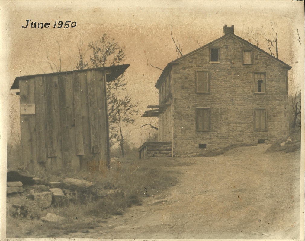
Building later renovated for use as Stein's Hollow Beagle Club
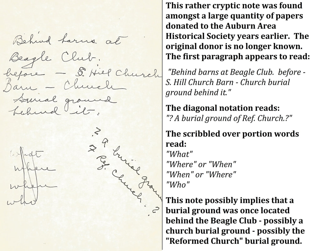
Cryptic note alluding to possible cemetery behind the Beagle Club
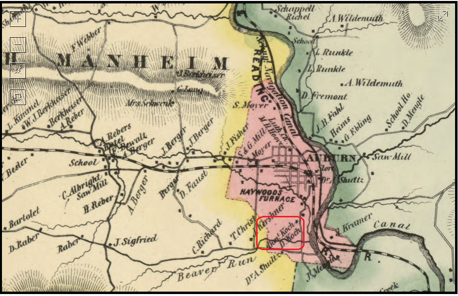
1863 Map of the Auburn area - the section within the red parameters is where the cemetery would have once been located.
|
**************************************************************
|
Mystery #004 -"The Enigmatic Enterprise"
This early photo (believed to be taken between 1885 and 1910) shows the structure located at 133 Market Street in Auburn. The variety of wares featured within the large display windows suggest a retail store and the sign mounted above the cellar entry hatch (in the bottom left quadrant of the picture) clearly states a restaurant is located within the building, but as of this date the members of the Auburn Area Historical Society have been unable to properly identify the name of this combination restaurant and store. Do you know anything about "the Enigmatic Enterprise"? If so, please use the button featured below to access our contact page titled "Visitor Input" and let us know. |
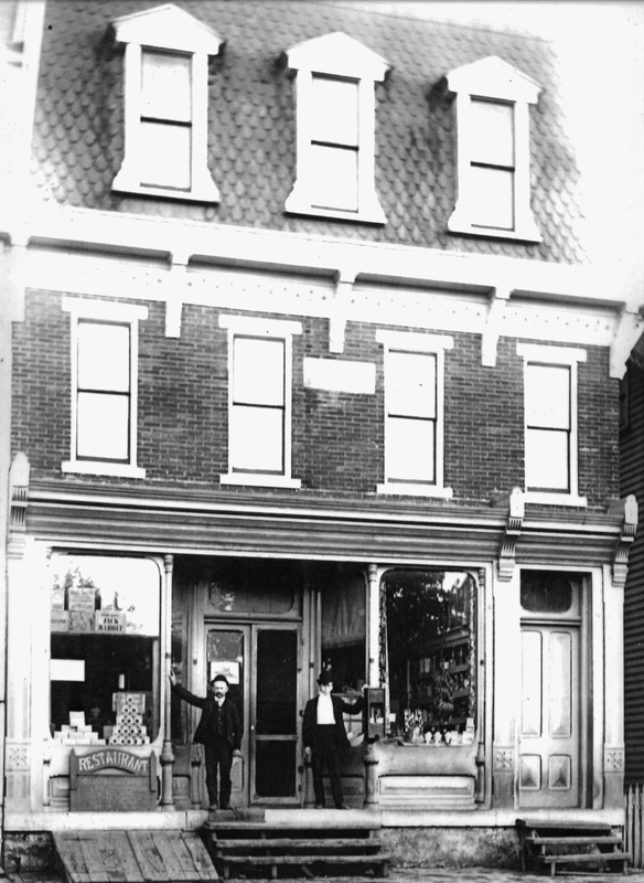
This combination restaurant and store once located at 133 Market Street has yet to be positively identified.
|
**************************************************************
|
Mystery #005 - "The Praying Church"
The small white structure featured in the adjacent picture was once a place of worship referred to with the nickname of "the Praying Church" because the congregants were unusually frequently praying during their attendance there. However, although the existence of this place of worship has been confirmed, the Auburn Area Historical Society has been unable to learn the actual name of this church or its religious affiliation. An unconfirmed rumor states that it may have been called the "Church of Apostolic Faith". Do you know anything about "the Praying Church"? If so, please use the button featured below to access our contact page titled "Visitor Input" and let us know. ************************************************** Update - A handwritten note found within the A.A.H.S. archives provides both additional information and seemingly contradictory information to our mystery of "The Praying Church". The note implies that "The Praying Church" was located in the structure at one time occupied by Al Geeseman's store on Market Street. Yet an elderly woman with excellent mental facilities had previously identified this small white structure on Washington Street as being the one to which was referred as the "Praying Church", even to the extent she recalled peeking inside the windows with friends while the church was in service. The church announcement board (featured at right) was supposed to have been the name of the "Praying Church", yet it was recovered from the basement of the structure on Market Street. A possible explanation would be that the church/congregation migrated from a prior structure (probably the Washington Street location) to a latter structure (probably the Market Street location since that is where the sign board was abandoned) at some point during its existence. A couple of other informational points on the handwritten note included what appears to be a partial list of congregants (Abraham Kramer; the Grover's whose one son was Lyle and one daughter was Anna; the Lester Carl family and the Steinerts), as well as the name Pastor Wetterscog or Wetterskog. An Abraham L. Kramer (1912-1938) is interred in the Auburn Church of God Cemetery, Cemetery Road, Auburn, PA but it is uncertain as to whether or not this is the same "Abraham Kramer" listed as having attending the "Praying Church". While this information is helpful, we could still use some clarification on this mystery. |
The small white structure featured here was once a place of worship referred to with the nickname of "the Praying Church"
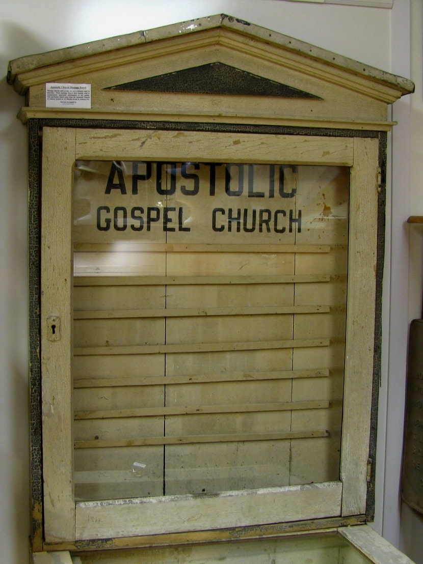
This vintage church memo board was recovered from the basement of 115 Market Street, the prior site of Al Geeseman's store and the prior alleged site of the "Praying Church".
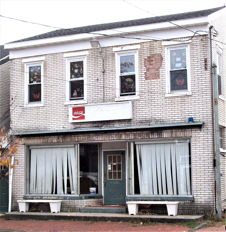
This building in a sad state of disrepair is located at 115 Market Street in Auburn, PA and was once the prior site of Al Geeseman's store and possibly the prior site of the "Praying Church". Fortunately, the owner of the structure has made modifications to the structure since this picture had been taken which makes the building more visually appealing.
|
**************************************************************
|
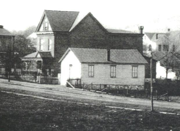
Mystery #006 - "The Healing Church"
The brick structure featured in the adjacent picture was once a place of worship referred to with the nickname of "the Healing Church" because people with illnesses or injuries were allegedly cured through "faith healing". One witness relates how a woman was once seen walking toward the church carrying a pair of crutches. Before entering the church, she placed the crutches beneath her armpits and piteously hobbled her way inside. She was miraculously "cured" of her infirmity and triumphantly walked out of the building carrying her crutches in one hand...much the same way she approached the church in the first place! Do you know anything about "the Healing Church"? If so, please use the button below to access our contact page titled "Visitor Input" and let us know. *************************************************** Update - A handwritten note found within the A.A.H.S. archives states the "Healing Church" was once located at the structure later occupied by "Cal Dewald" on Orchard Street. The note also documents that an "Eva Smith", mother of "Mary Lou Smith Aungst", was "on crutches" and was "healed - able to walk". Auburn-area amateur historian Kermit Mengel once related a story about what is presumably this same "healing". Although he did not name the individual during its retelling, the story stated that the woman was observed from a distance walking normally toward the church and carrying her crutches in one hand. When she was within a reasonable distance, she began using the crutches and hobbling along piteously. She wobbily entered into the "healing" church, waited patiently to be "healed", and then "miraculously" walked from the church carrying her crutches...much like she had originally approached the church to be "healed". Whether this is the same individual who was mentioned in the above-documented alleged "hoax" is unknown. A final entry states that the "nick-name" for this church was the "belly-rubber school". (Editor's note: which is apparently a nickname for an already nick-named church). While this additional information is interesting, none of it helps to positively identify the official name of the church nor provide us any further actual details about the church, congregation, dates of operation, etc. |
The squat brick structure featured here was once a place of worship referred to by the nickname of "The Healing Church"
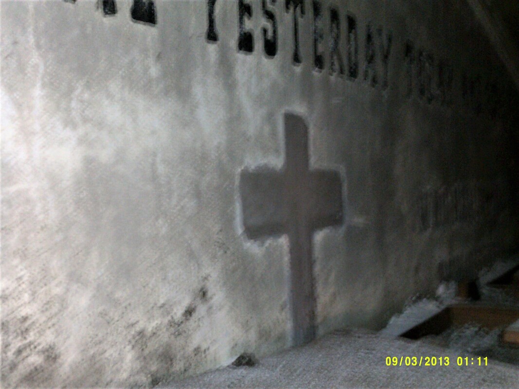
The north interior wall of the structure contains a cross and biblical quote painted upon it near the peak of the roof. The verse, Hebrews 13:8 of the King James Version of the Bible, reads "Jesus Christ the same yesterday, and today, and forever". This cross and scripture are hidden from public view by the installation of a lowered ceiling when the building was converted into a private residence but can still be observed in the attic crawlspace.
|
**************************************************************
|
Mystery #007 - "The Reclusive Road"
(see below in "What We DO Know...") |
**************************************************************
|
Mystery #008 - "The Man of Mystery"
(see below in "What We DO Know...") |
**************************************************************
|
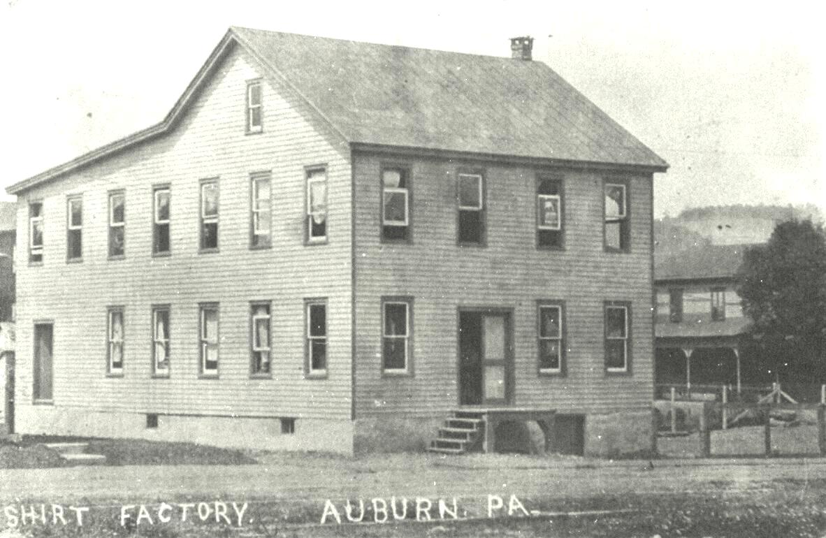
Mystery #009 - "Those Taxing Textiles..."
Auburn had its share of the textile industry over the decades. However, exactly how big Auburn's share truly was is uncertain. Several textile factories are historical fact. Other textile factories are less clear in their alleged existence or simply the same factory being referred to by a "common", unofficial or even different name. Still others are nothing more than a vague memory of a possible textile business described in its most general term or approximate location. If you can help us sort which of these factories are historically accurate or provide us with further information about a specific factory, please contact us using the "Visitor Input" button featured below and help us unravel this ball of yarn. *"Auburn Hosiery Mill, Inc." - other than an on-line reference that such a business existed in Auburn, PA, there is little other information available. *"Auburn Shirt Company factory" (definite) - 100 block of Washington Street - little information available; uncertain if this was the actual name. *Auburn Shirt factory (possible) - based on a vague single picture; uncertain as to whether or not this establishment was actually in Auburn, PA. See this webpage's Mystery #017 - "The (Original?) Auburn Shirt factory" listed below for more details. *Diefenderfer's sewing factory - believed to have been an unofficial/common name for the Auburn Knitting Mills owned by the Diefenderfer family. *"GEM Undergarment Company, Inc." - reference to the Auburn area but no further information avail. *"Jyll Industries" - reference to the Auburn area but no further information is available *"L' Art De La Mode, Inc." - reference to the Auburn area but uncertain whether this actually had any ties to the textile industry. *Necktie factory - historic references to a "necktie" factory (pre-Auburn Knitting Mills), but unclear of actual location or proper business name. *"Nester Knit" - little information available but it has tentatively been identified as having been located at the east end of Orchard Street. *"Nice Knitting Mills" - promotional pencil found, believed to have possibly occupied the same structure as the Auburn Knitting Mills, no real information available *Orchard Street knitting mill - Small brick structure located in the 100 block of Orchard Street, actual business name uncertain but has been tentatively identified as possibly being the location of the "Nester Knit" factory. Believed to have possibly made silk stockings, same building once used as an off-denominational church briefly. *Silk stocking factory - (see: "Nester Knit; Orchard Street knitting mill listed above) *"Windsor Knitting Mill, Inc."- found sign in an Auburn factory building but uncertain whether the knitting mill was located in that building - no information available. *"Wright's Knitting Mill" vs. "Wright's Knit Wear" - found references for both names, uncertain as to whether these industries were one and the same, separate, or an evolution of one company to the other company. |
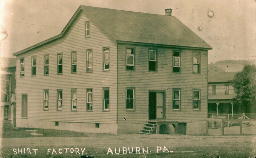
Vintage postcard identifying a house located in the 100 block of Washington Street, Auburn as a "shirt factory".
Possible Auburn Shirt factory picutre
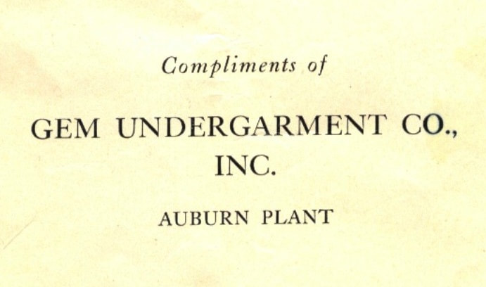
Gem Undergarment Company, Inc. advertisement snippet
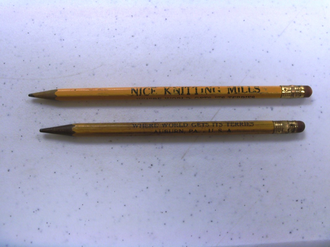
Two advertising pencils for "Nice Knitting Mills" (believed to have been situated at an unidentified location in Auburn)
Orchard Street knitting mill and possibly a silk stocking factory; tentatively identified as "Nester Knit"
Windsor Knitting Mill, Inc. sign found within an abandoned factory building located at the corner of Bear Creek Street and Pine Street.
|
**************************************************************
|
Mystery #010 - "The Sacrosanct Cemetery"
(see below in "What We DO Know...") |
**************************************************************
|
Mystery #011 - "The Baffling Brothel"
"Bagnio, bawdy house, bordello, brothel, call-house, cat-house, den of iniquity, den of vice, house of assignations, house of ill fame, house of ill-repute, house of prostitution, joy house, massage parlor, house with a red door, house with a red-light, red-light district, whorehouse"...the synonyms for structures in which sex is exchanged for money (or other forms of compensation) are plentiful. What isn't as plentiful is specifics about one such business reputed to have plied its trade outside of Auburn but within the "Auburn-area". Here are the few unconfirmed details we have...(1) the place was nicknamed "The Sugar Shack"; (2) the Sugar Shack was located northeast of Auburn in the general vicinity of Ash Lane; (3) the Sugar Shack operated in the mid-1900s; (4) the Sugar Shack was staffed by at least two women whose identities are currently unknown (or at least undisclosed); and (5) several unconfirmed sources claim to have knowledge that the Sugar Shack did exist but claim they personally didn't have "intimate" knowledge regarding the Sugar Shack. Do you have any information regarding the Sugar Shack? We are looking for confirmation of its existence, an exact location of the structure, dates of operation, quantities and identities of the women who "worked" there, or any other relevant information you may have. If you have any such information, please use the Visitor Input button featured here to submit the details to our website. You can submit the information anonymously if you choose to do so. |
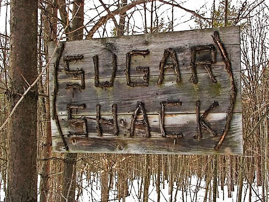
This sign, while applicable, is NOT affiliated with the "Sugar Shack" once located in the Auburn-area.
|
**************************************************************
|
Mystery #012 - "The Stumping Structure"
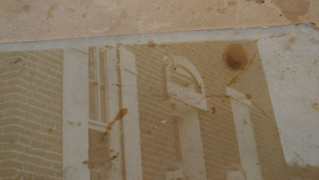
An 1875 DeBeer's Atlas map of Auburn, Schuylkill County, Pennsylvania appears to show a significantly large structure located on the southwest corner of Franklin (now Second) and Market Streets. (See adjacent picture - structure framed in red). The building appears to occupy two parcels of land frontage adjacent to Market Street. This property is currently vacant of structures with no apparent indications of a prior building or even its foundation. A later photograph of the one-time residence of Guy Diefenderfer (which is located at 209 Market Street) appears to show a reasonably large, two-story structure, possibly brick, to the east side of the Diefender home between it and Second Street. The structure seems very close to the Diefenderfer house, separated by mere feet in distance. This placement would correspond with the location of the building depicted on the 1875 map. However, no known record exists of the building, its occupants, it purpose or when it was razed/removed. Do you know anything about "the Stumping Structure"? If you have any information on this "Stumping Structure", please let us know using the "Visitor Input" button below. Update: Auburn Area Historical Society Lifetime Member Ken Heinbach recalls having been inside the structure many decades ago and stated it was a family residence. If anyone has additional information regarding ownership or occupants of this house, please let us know so we can update our website and "solve" this mystery!
|
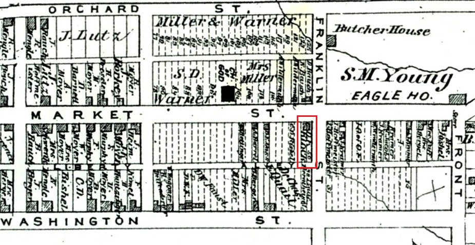
This enlargement of an 1875 DeBeers Atlas map of Auburn, Schuylkill County, PA shows an unfamiliar structure (framed in red) located at the southwest corner of Franklin (now Second) and Market Streets
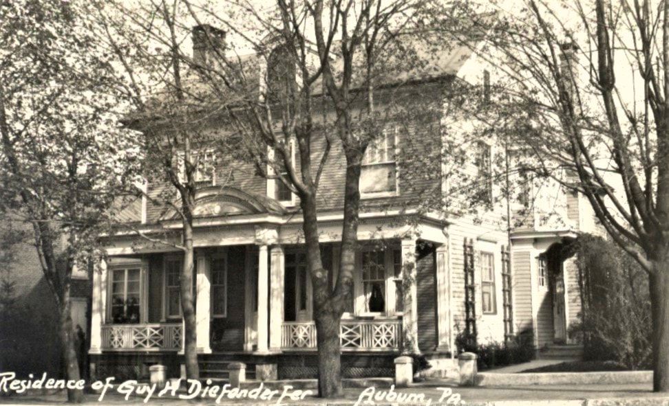
This photograph of the Diefenderfer residence, situated at 209 Market Street, Auburn, PA, appears to show an unfamiliar two-story (possibly brick) structure to the east of it between the Diefenderfer house and 2nd Street. This parcel is now vacant of any such buildings.
|
**************************************************************
|
Mystery #013 - "The Chiseled Church"
(see below in "What We DO Know...") |
**************************************************************
|
Mystery #014 - "The Movie Star Mystery"
(see below in "What We DO Know...") |
**************************************************************
|
Mystery #015 - "The Heavenly Recruits"
"The Heavenly Recruits" of Auburn, Pennsylvania are mentioned in news articles dated 1892 as well as in the Auburn Business Directory dated 1905 under the category of "churches". In 1905, at least three churches are known to have been established...the "Auburn Church of God", the one sometimes referred to as the "Community Church of God", and St. John's Lutheran and Reformed Church. However, it's also known that other small, less established churches existed to include the "Apostolic Church of God", and ones nicknamed the "Healing Church" and the "Praying Church" but whose proper names are unknown currently. The 1905 Business Directory lists the "Heavenly Recruits" along with "St. John's Lutheran and Reformed" church and a second entry simply titled "Church of God"...but doesn't specify which "Church of God". So, we don't know for certain which "church of god" is mentioned, nor if this group referred to as the "Heavenly Recruits" is, in fact, the other "church of god", or perhaps from one of the other churches previously mentioned, or even another congregation not yet factored into our grouping. Do you know anything about "The Heavenly Recruits"? If you have any information on the group from the 1890s & 1900s referred to as "the Heavenly Recruits", use the "Visitors Input" button located here and let us know! |

|
|
UPDATE: The website https://dtimeshistory. blogspot.com, under the titled Delaware County History, has a dated article from August 22, 1895 about a "Heavenly Recruits" meeting in which one of the many featured guests speakers would be a Reverend H. M. Tengle of Auburn, Pa. The assumption might be that Tengle was the leader of the Heavenly Recruits chapter located in Auburn at the time of the article's publication.
|
**************************************************************
|
Mystery #016 - "The Grave-digging Hermit" (see below in "What We DO Know...")
|
**************************************************************
|
Mystery #017 -
"The (Original?) Auburn Shirt Factory" The vintage picture featured on the right of this entry is assumed to have been a photograph of an early shirt factory located somewhere in Auburn, Schuylkill County, Pennsylvania. By enlarging the section of the picture above the door frame, the words "Auburn" and "Shirt" are barely legible. On the back of the picture is a faint signature of an "Ella Gruber" and possibly a date. This is accompanied by what appears to be a later notation which states "Ella Gruber" and "Auburn, PA". An Internet search for the name "Ella Gruber" of this era and "Auburn, PA" failed to produce any results. A search of the website findagrave.com also failed to list any female with the name "Ella Gruber" (either maiden name or married surname) of this era as having been interred anywhere in Schuylkill County, PA. The same lack of result on that website occurred when searching variations of the first name such as "Arabella", "Ellen", "Isabella" or "Maribella". The first name variation of "Elizabeth" was also searched for interments in Schuylkill County and five were found for this era, but none of them had any obvious ties to the Auburn-area. The possibility exists that this "Auburn" factory may have been located in one of the "Auburn"-variations found in Pennsylvania like Auburn Center, Auburn Four Corners, Auburn Township, South Auburn or West Auburn, all of which are located in Susquehanna County, Pennsylvania. Or possibly the "Auburn" over the door frame indicated an "Auburn" from a different state which contains a town of that name like Alabama, California, Colorado, Georgia, Illinois, Indiana, Iowa, Kansas, Kentucky, Maine, Massachusetts, Michigan, Mississippi, Missouri, Nebraska, New Hampshire, New Jersey, New York, North Carolina, North Dakota, Oregon, Rhode Island, Texas, Washington, West Virginia, the two in Wisconsin, or Wyoming and the picture was erroneously notated on the back with the presumption that it was from "Auburn, PA". The truth is, we simply do not know at this time. However, we are fairly certain that this is not the same "Auburn Shirt Factory" located on Washington Street which was featured on an early vintage postcard because the structural features of the buildings are too dissimilar. Do you know anything about "The (Original?) Auburn Shirt Factory"? If you have any information on this shirt factory, please let us know using the "Visitor Input" button below. |

This vintage picture is assumed to have been a photograph of an early shirt factory located somewhere in Auburn, Schuylkill County, PA
In this enlargement of a portion of the above-feature picture, the words "Auburn" and "Shirt" are barely legible on this signage above the door

Unfortunately, we do not know if "Ella Gruber" was one of the employees of this shirt factory or simply claiming ownership of this early photograph
Vintage postcard of the Auburn Shirt Factory located on Washington Street in Auburn.
|
**************************************************************
|
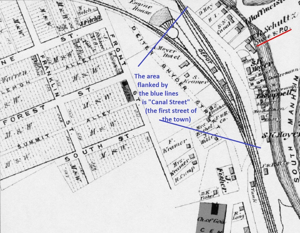
Mystery #017 - "The Stymieing Store"
An 1863 Map of Auburn shows a structure labeled "store" (highlighted by the red arrow) between Canal Street and the Schuylkill Canal, in a straight line due east of Pine Street (see the imposed red line following Pine Street west to east), and located at the corner of where Canal Street originally bends away from Pine Street. It is also due north of the unnamed road leading from Canal Street directly to the edge of the canal. There is no indication as to whom owns the store or what merchandise it might sell. By 1875, the DeBeers Atlas Map of Auburn (admittedly a more professional drawn map), no structure is located at the spot where the 1863 store was indicated. Following Pine Street in a straight line due east to the canal (see the red line imposed upon Pine Street), the location is void of any structures. The imposed red arrow points to the location across the canal where the store would have been located on the 1863 map. Additionally, there is no structure located near the corner where Canal Street originally bends away from where Pine Street would have been extended. A possibility exists that a store was once located at that vacant spot but was razed, possibly to build a new, larger store elsewhere along the street or in the newly forming town. A second possibility is that the 1863 map cartographer (a person who draws maps) made a fairly significant error on their map and placed the store one block further northwest than it should have been. One block southeast of that location can be found a structure on the 1875 map labeled "I. Hoffmeister". If you travel one block south from Pine Street, you would be on Forest Street. Extending a straight line due east from Forest Street (see the blue line imposed upon the picture), you'd just miss the Hoffmeister structure. Although inexplicably it isn't labeled as a store, records indicate that an Isaac Hoffmeister was operating a store along Canal Street by 1886 if not earlier. A Pottsville Republican newspaper snippet dated January 28, 1886 reads "Isaac Hoffmeister, Esq., the veteran store keeper at Auburn, was in town this morning and paid his respects to the REPUBLICAN office". Whether a "veteran" store keeper would qualify him as having owned and operated the store pictured on the 1863 map twenty-three years earlier is uncertain. Isaac would have been in his early forties at that time, a reasonable age for a shopkeeper in 1863. The question arises, was there a previous store at that geographic location in 1863 that no longer existed by 1875, or did the cartographer make a significant error on the 1863 map and erroneously place Isaac Hoffmeister's store? Without further records, there may not be a conclusive answer to this question. Do you know anything about "The Stymieing Store" or even have an opinion on the variance between the two maps? If you have any information on this store, please let us know using the "Visitors Input" button featured here. |
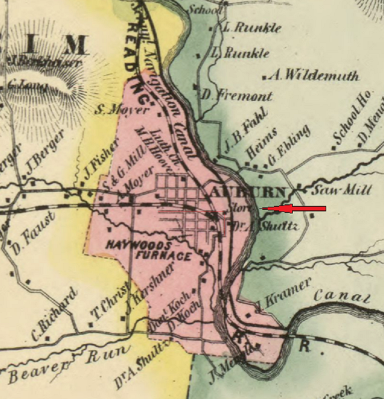
An 1863 map of Auburn showing a structure labeled "store" (highlighted by the red arrow) between Canal Street and the Schuylkill Canal, and in a straight line due east of Pine Street (see the imposed red line following Pine Street west to east) and located at the corner of where Canal Street originally bends away from Pine Street.
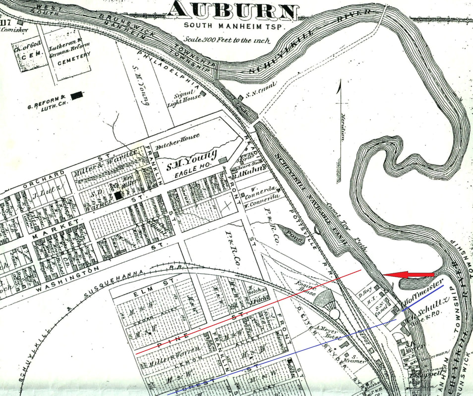
An enlargement of a portion of the 1875 DeBeers Atlas Map of Auburn shows a vacant area where the mystery store was located on the 1863 map (as indicated by the red arrow). Following the blue line out from Forest Street, it barely misses a structure labeled "I. Hoffmeister"...who is believed to have operated a store on Canal Street by 1886 if not earlier.
|
**************************************************************
|
Mystery #19 - "The Distant Dairy"
Auburn Area Historical Society Lifetime Member Brian Bohr brought the adjacent milk bottle to the attention of the website manager. The "Wood Glen Farms" appears to be a relatively unfamiliar dairy operation to any Auburn-area residents. The milk bottle is clearly embossed with the letters "AUBURN, PENN.", but no one from the immediate Auburn-area seems to have any actual knowledge of this dairy. Occasionally, the Internet will erroneously post something labeled as "Auburn, PA", implying it is affiliated with the Auburn, Schuylkill County, PA area when, in fact, the misidentified item actually has ties to either Auburn Center, Auburn Four Corners, Auburn Township, South Auburn or West Auburn, all of which are located in Susquehanna County, Pennsylvania. So, the question arose, is this milk bottle relevant to the Auburn which is located in Schuylkill County, or was the milk bottle something which belonged to the Susquehanna County area "Auburns"? Brian used his network of contacts to come up with some preliminary conclusions. First, Schuylkill Haven historian and collector Richard Nagle applied his research skills to discover a single mention of the dairy in "The Call" newspaper (Schuylkill Haven, Schuylkill County, PA) from 1928. That discovery helped to confirm that the dairy was probably affiliated with Schuylkill County, rather than the distant Susquehanna County (approximately a 100-mile distance). (On a side-note, Richard has been a guest speaker of presentations for the Auburn Area Historical Society on multiple occasions, as well as for other organizations, and provides informative, well-researched and entertaining topics). Brian conferred with Auburn Area Historical Society Lifetime Member Carl Boltz, who is also the undisputed milk-bottle collector, and milk-bottle expert, of Auburn, and possibly of all Schuylkill County, having approximately 1,000 milk bottles in his collection. Carl states that he believes the Wood Glen Farms was a dairy operation that was somewhat distant from Auburn, Schuylkill County, PA. He theorized that Wood Glen Farms bottled the milk in those bottles specifically to be shipped to, and sold in, the Auburn area. As a result, even though the dairy itself was not located within the immediate Auburn-area, the operation is mentioned on this webpage because of its affiliation to the town of Auburn, Schuylkill County, PA. Do you know anything about "The Distant Dairy"? If you have any information on this dairy operation that might shed some light on its location, period of operation, or other factors, please let us know by using the "Visitor Input" button located here. |
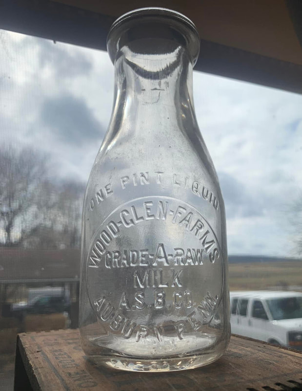
A Wood Glen Farms "Grade A Raw Milk" dairy bottle embossed "AUBURN, PENN."
|
**************************************************************
What We DO Know...
|
What we do know...is not much. However, listed below are some of our prior "Do You Know..." entries for which we have received some form of an answer or partial enlightenment. A few of our "Mystery of History" entries have received a "new clew". As a result, those entries are now transferred into this lower section.
|
**************************************************************
|
Mystery #001 - "The Frustrating Furnace"
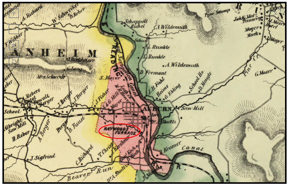
This 1863 map depicting early Auburn, Pennsylvania emphasizes three major commercial businesses using a large bold print. The first is the famous Reading Railroad (which was subsequently immortalized during the Great Depression in the board game of Monopoly). The second was the slightly less famous but still well-known Schuylkill Navigation (Canal) System. Considering the prominence of these two once-powerful companies, it would stand to reason that the third commercial business would also be familiar to many people...yet very little information exists currently about "Haywoods Furnace" which was once located just south of Auburn. A Reverend Benjamin Haywood was an entrepreneur in Schuylkill County who, among other ventures, operate iron foundries in Pottsville and Palo Alto. Whether this "Haywoods Furnace" has any direct affiliation with the Reverend Benjamin Haywood is uncertain. Do you know anything about "the Frustrating Furnace"? If so, please use the button to access our contact page titled "Visitor Input" and let us know. |
The Frustrating Furnace
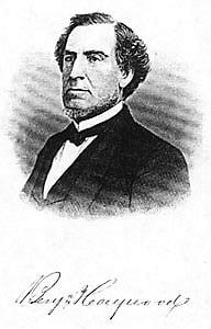
Reverend Benjamin Haywood
|
|
Update:
The "Mystery of the Frustrating Furnace" appears to have been solved. An 1863 map depicted a notation for a "Haywoods Furnace" south of Auburn, PA, yet no other historical record, recollection, map or structure indicated that an industrial furnace every existed in that general location. A recent discovery of an "EXECUTOR'S SALE" notice, believed to have been copied from a digitized scan of an 1800s Miners Journal newspaper, listed the private sale of property owned by Benjamin Haywood "situated within the limits of the borough of Auburn". Adjacent to this webpage entry you can view the scan of the entire notice, but to summarize, Benjamin Haywood apparently purchased the property pre-1863 with the intent of establishing an iron furnace at this location, but by his death in 1878 had not yet accomplished this goal. The notice implies the property would be a good site to establish such a furnace, but a detailed listing of all structures, geographical features and selling points of the property fails to list an existing furnace on site. A later confirmation of such a supposition was found in the Reading Eagle edition dated November 12, 1879 in which the article was addressing the revival of the "iron business" and reads in part "A place better located than Auburn for such an enterprise, or any other kind, could not easily be found. Two creeks empty into the Schuylkill river at this point, which affords plenty of water for any kind of works. The best location is within a stone's throw from the main line of the P. & R. railroad, and the junction of the S. & S. branch, a site that was purchased by the late Benjamin Haywood, of Pottsville, for the purpose of erecting iron works, but on account of some heavy loss and the depression of the iron trade he abandoned the project." The assumption is that the cartographer of the 1863 map learned of Haywood's intent to install such an establishment on his property, and considering Haywood's impressive record for entrepreneurship over his life time, felt he was justified including "Haywoods Furnace" on the map even though it had not yet been constructed. He was wrong. The "Haywoods Furnace" map entry may be one of the few authentic examples of "Fake News". |
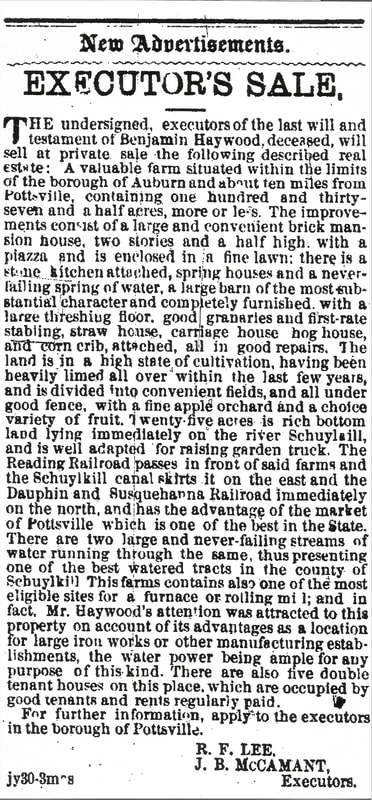
A copy of the "EXECUTOR'S SALE" notice for Benjamin Haywood's property in Auburn, PA
|
**************************************************************
|
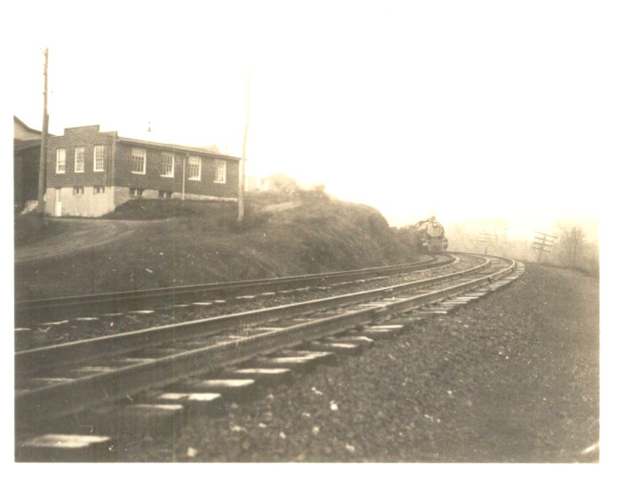
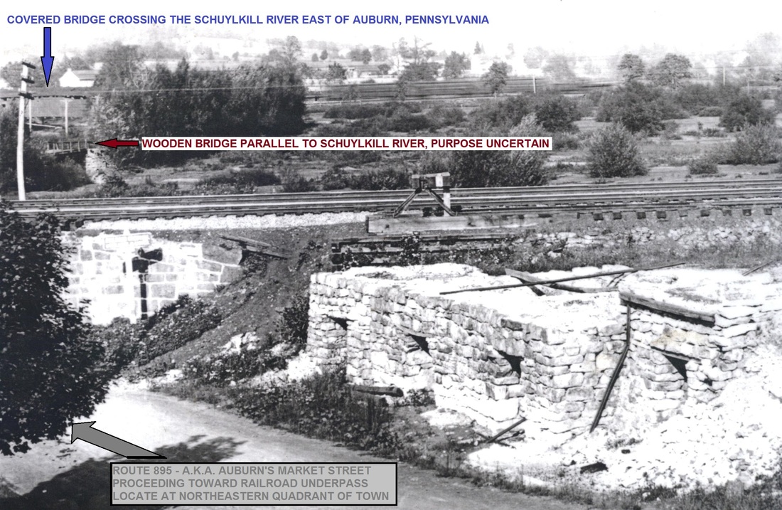
Mystery #002- "The Baffling Bridge"
The picture on the right can be "clicked upon" to enlarge it for easier viewing. In the top left corner of the picture you will see the old wooden covered bridge which crossed the Schuylkill River east of Auburn in the general area of today's modern bridge. In the bottom left foreground, you can see Rt. 895 (Market Street of Auburn) as it is about to proceed beneath the Railroad overpass while traveling east out of Auburn. However, if you look in the top left corner directly beneath the covered bridge, you will see our "mystery bridge"...a bridge-like structure running at an opposing angle to the covered bridge and located somewhere between the covered bridge and the railroad overpass. Presently, there is no indication of that bridge or its exact location. There isn't even any obvious geographical anomaly which would require a bridge in that location. One possibility was forwarded that perhaps it was some type of loading dock related to the nearby coal washery. Another recent theory is that it might have been part of the Schuylkill Navigation System's ("Schuylkill Canal's") infrastructure. Do you know anything about this "baffling bridge"? Or, do you have any vintage photographs of this area that might more clearly depict the structure? If so, please use the button to access our contact page titled "Visitor Input" and let us know. |
The Baffling Bridge
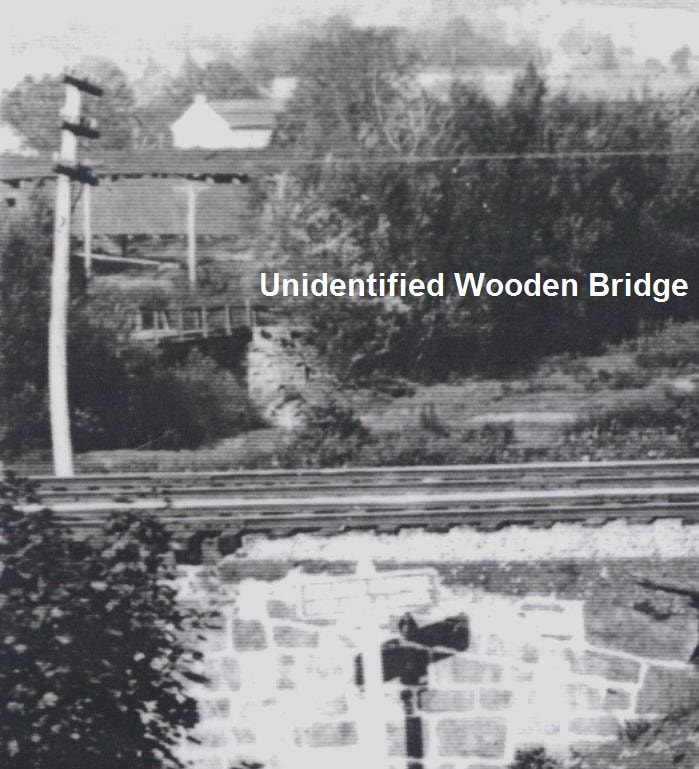
A closer look at the "Baffling Bridge"
|
|
Update:
A vintage narrative titled "Things I remember of Auburn" by prior resident Verna Geesaman might provide a possible clue as to the nature of this bridge. In this four page document, Verna is discussing the Delaware Seamless Tube Company which was located adjacent to the eastern bank of the Schuylkill River east of Auburn. An excerpt from her recollections state "There was a nice path from town (Auburn) to the (Delaware Seamless Tube Company) mill. There was a wooden bridge and a covered bridge because the Pennsylvania (Railroad) Station was over at the mill." The "covered" bridge is obviously the bridge in the distance as this was the only known "covered" bridge over known to have spanned the river near Auburn. Verna's statement did not clarify whether the "wooden bridge" also crossed the Schuylkill River or simply a smaller geographical feature like a stream or gully. However, logic dictates that the implication would be that it did not cross the river since not only would that be an unnecessary redundancy of a major engineering effort within such a relatively short distance, but more importantly, Verna was discussing a single path at that time meaning the bridges would be featured consecutively along the course of the path. Additionally, by stating the path went from "town to the mill", she also might list the bridges sequentially as if proceeding in that direction of travel, meaning a traveler on this path would first cross "a wooden bridge", and then cross "a covered bridge". Currently, it is unknown what geographical feature might have been present at that time which required a wooden bridge at that location as presently no such obstacle exists, however, Verna's statements seem to indicate the mystery structure may very well have been the wooden bridge to which she refers. An early "blue print" style map of the area includes a depiction of the main road from Auburn heading east from the railroad underpass (now known as Rt. 895) appearing to have some type of geological anomaly (perhaps a inlet from the Schuylkill River or a gulley of some sort) dissecting the road at the approximate location of the mystery bridge. If this map can be trusted to be accurate, a bridge spanning this unknown anomaly may explain the existence of the mystery bridge. (see map pictured on right) We're still looking for definitive proof or identification of this structure, but perhaps Verna's memories of long ago have shed a little light on the mystery. |
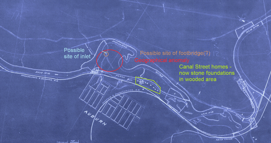
A "blue print" style map of the area showing some type of geological anomaly at the approximate location of the mystery bridge
|
**************************************************************
|
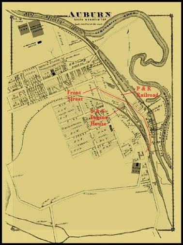
Mystery #007 - "The Reclusive Road"
The 1910 U.S. Census for Auburn, Pennsylvania lists in its border a road referred to as "Railroad Street" within Auburn. (See census record on right). However, the 1875 DeBeers Atlas Map of Auburn does not list a "Railroad Street" (see Atlas enlargement on right) nor does any current map of Auburn. Therefore Auburn's "Railroad Street" has strayed off into history. Logic would dictate that the street would have been located adjacent to railroad tracks or a railroad station/structure. Below is a depiction of known Auburn Streets both past and present. Those that might have been possible candidates for our mystery Railroad Street have been delineated in red. Elm Street is delineated but is an unlikely candidate since it was named "Elm Street" in 1875 and still has that same name presently. A few of our more active historians suggest it might have been another name (possibly a later name) for Canal Street but we'd like to confirm its exact location. Do you know anything about Railroad Street? If so, please use the button to the right to access our contact page titled "Visitor Input" and let us know. 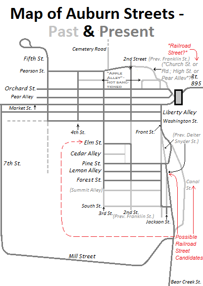
Past and Present Streets of Auburn, Pennsylvania (both official and unofficial names)
|
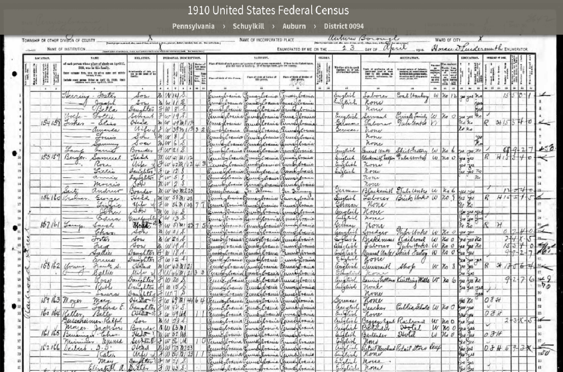
1910 U.S. Federal Census records for Railroad Street, Auburn, Pennsylvania
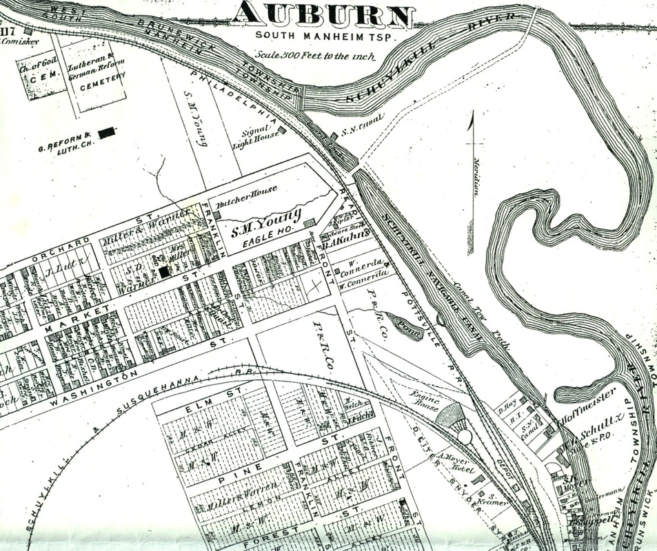
1875 DeBeers Atlas Map of Auburn, Pennsylvania
|
|
Update -
The "Reclusive Road" isn't reclusive any longer. While reviewing Auburn Borough Council minutes (or notes) from a meeting conducted on December 8, 1882, the following entry was discovered "St. running from Front around S & S engine house & crossing P & R railroad shall be called Railroad st.". In other words, on this date a motion had been made by the borough council to officially name the "St." (street) which ran from Front (Street) around the S & S (Schuylkill and Susquehanna Railroad) engine house & crossing P & R (the Philadelphia and Reading) railroad shall be called Railroad St. (street)". This previously "officially" unnamed street basically tied Front Street to the road previously referred to commonly as "Canal Street" which in turn rejoined what would later become known as Bear Creek Street. Very little of this roadway still exists today. |
Railroad Street is tentatively designated with red lines on this 1875 DeBeers Atlas map (approx. seven years prior to the street being named).
|
**************************************************************
|
Mystery #008 - "The Man of Mystery"
Who was "Deiter Snyder"? According to the 1875 DeBeers Atlas for Auburn, Pennsylvania, one of the streets in town was assigned the name "Deiter Snyder Street"...at least on this map if not officially or permanently. "Deiter Snyder Street" may have even been named prior to Auburn having become established in 1857. The street was located near the Schuylkill Canal as well as near the railroad tracks for both the Reading Railroad and the Schuylkill & Susquehanna Railroad, so he may have been important to one of those major enterprises. The street was later rerouted slightly and the majority of it was then renamed "Bear Creek Street". What we'd like to know is who he was, where he lived and what did he accomplish that resulted in the street being referred to by his name. Do you know anything about "The Man of Mystery" Deiter Snyder? If so, please use the button below to access our contact page titled "Visitor Input" and let us know. |
Enlargement of a portion of the 1875 Atlas depicting "Deiter Snyder Street" among other listings
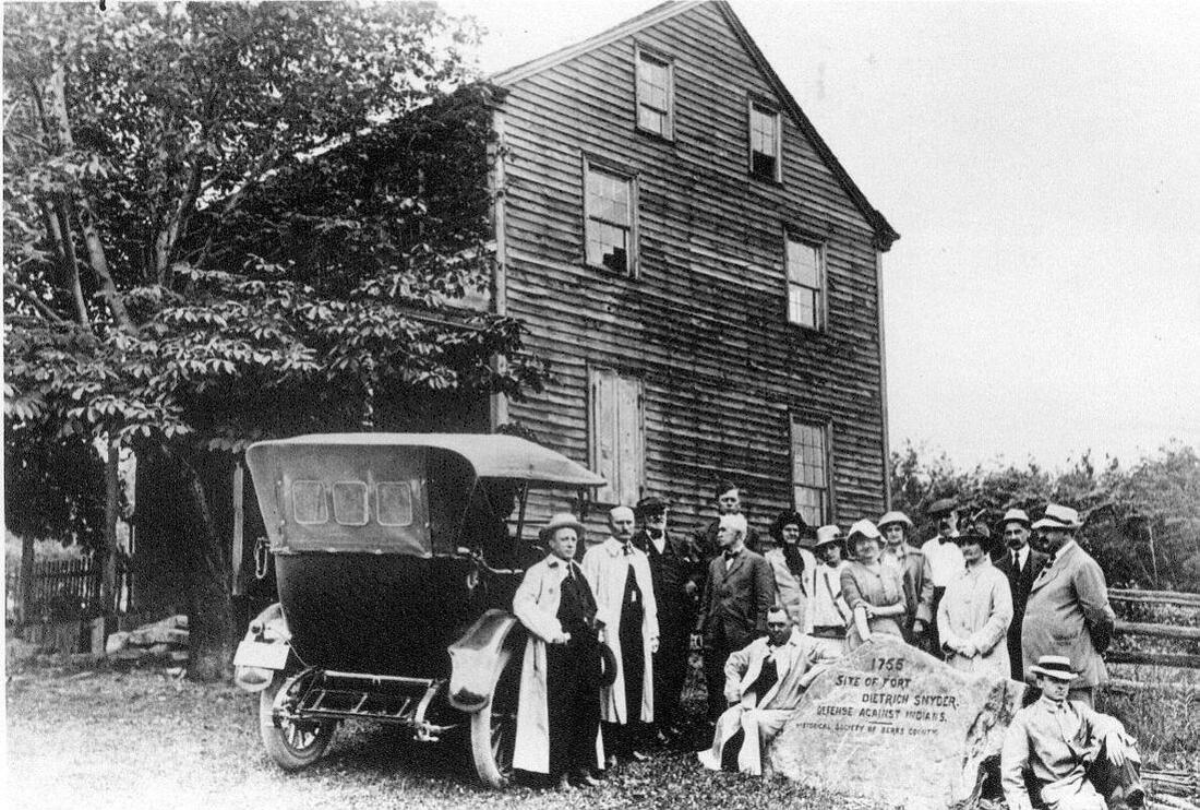
The original monument dedicated to "Fort Deitrich Snyder" located outside of the "Blue Mountain House" (hotel) in Schuylkill County. Neither the monument nor the hotel exist any longer.
|
|
Update -
AAHS Lifetime Members Brian Bohr, John Bambrick and Todd Graybill may have solved at least a portion of this mystery as a result of their diligence and research. Due to inconsistencies in spelling, which were the result of illiteracy, mistakes, phonetic spellings, poor record-keeping or simple variations of names, Deiter Snyder's name has many variations in local historical documents and references. For example, just the first name alone has been spelled as: Deiter - Detrich - Detrick - Didrich - Dieter - Dietrich - Dietrick - Ditrich. His surname (last name) is also found in several variations to include: Schneider - Sneider - Sneyder - Snider - Snyder. Since a person's name was frequently the only form of identifying the individual in these documents, facts cannot always be confirmed but certain assumptions can be reasonably made based on circumstantial evidence. A "Dieter Snyder" was born on May 2, 1757 in Alsace Township, Berks County, PA. His parents may have been Henry and Catharine (Bucher?) Schneider (Snyder), who are listed in records as having a son Dietrich (note: "Dieter" can be a "common" name or nickname for Dietrich just like "John" can be a shortened version of Jonathan). Dietrich had at least three brothers named Abraham, Leonard and Jacob Snyder. While Dieter was residing near Reading, PA, he enlisted in the Continental Army of the Revolutionary War sometime during May, 1776. He served as a Private in Captain Joseph Heister's company of Colonel Henry Haller's Pennsylvania Regiment. He was in the battles of Long Island and Trenton where he assisted in taking prisoners. He returned home on December 23rd, 1776, having served approximately six months. Dieter then moved to Richmond Township, Berks County, PA and served in the Militia approximately four months in Captain George May's Company of Colonel Lindenmuth's Pennsylvania Regiment. He was sent to Wyoming and Sunbury, PA to "quell the Indians" but the date of this tour of duty was not given. His brother, Jacob, also served in the Revolutionary War. Records indicate Dieter moved from Berks County to Schuylkill County, then possibly to Dauphin County for three years, before returning to Schuylkill County. The dates of these relocations are unclear; however, it should be noted that the geographical area which contains the vast majority of Schuylkill County was originally part of a much larger Berks County until Schuylkill County was formed from a portion of Berks County in 1811. A Didrich Sneyder was residing in "Ruscombmanor" of Berks County in 1790 according to Census Records. The 1800 Census Records list a Detrich Sneider as living in Pine Grove Township, Berks County, during that year while a similar record lists Dieter Snyder as living in Brunswick, Berks County the same year. This could be the listing which places Dieter Snyder in the closest proximity to Auburn. The 1810 Census lists a Deiter Snyder residing in Pine Grove of Berks County during the census. According to an 1820 Census for Mifflin, Dauphin County, PA, a Ditrich Snyder was a resident of that county. However, there was a Mifflin located in the Schuylkill County near the county border line, so there may be some discrepancy in these records. Further records show a Detrick Snyder residing in Schuylkill County in 1828 and a Dieter Snyder residing in Schuylkill County in Janurary of 1832 but a less generalized location isn't provided in those records. In October of 1832, Dieter Snyder was residing in Lower Mahantango, Schuylkill County according to his military pension records which stated that he was granted an annual military pension of $40/year. By July of 1833, a Dieter Snyder was listed as living in Wayne Township, Schuylkill County. Records indicate that a Dieter Snyder died in 1837. Records indicate that a one-story log cabin was once situated in present Wayne Township near the peak of the Blue Mountains. Folklore stated that this cabin was inhabited by a Dietrich Snyder during the French and Indian War (circa 1755 - 1763) and was utilized as a "look-out" or "watch-tower" for Native American hostilities. Although this structure doesn't appear on any contemporary maps until decades after the French and Indian War ended, and although the Dieter Snyder who was born in 1757 lived in Alsace Township until well after the war ended, the cabin was later referred to as "Fort Dietrich Snyder". Over a century later, the Berks County Historical Society erected a monument on site in its honor in 1905. This controversy was addressed at a program presented to the Auburn Area Historical Society by A.A.H.S. Chairperson Todd Graybill titled "Fort Dietrich Snyder: Fact or Folklore". The program concluded that after extensive research, the folklore regarding Fort Dietrich Snyder was not factual and that the structure didn't even exist during the French and Indian War. While there is record of a Dietrick Snyder having been born in 1720 in West Hamburg, Berks County and who is believed to have died in 1817, it is unclear as to whether this cabin actually existed during the French and Indian War since there was no mention of the "fort" or even the cabin in any known records of that time. Nor is there any record of a Dietrich Snyder having served in the French and Indian War. However, by 1843 a map of the Auburn area depicts a roadway with the notation "Public Road leading to Dieter Snyder on Blue Mountain". This road is, in part, now the present Deer View Drive located south of Auburn. Theoretically, the road depicted in the 1875 Atlas Map of Auburn referred to as Deiter Snyder Street may have been given the name since that road would eventually intersect with Deer View Drive ("the Public Road leading to Dieter Snyder on Blue Mountain") and eventually lead to the cabin of Dietrich Snyder (an approximate 10 1/2 mile journey). Exactly when the street was once named after Deiter Snyder is uncertain. Additionally, the reason why the street was named is unclear as well. At least three separate possibilities exist...(1) the Deiter Snyder Street which was once in Auburn (now Bear Creek Street) intersected the "Public Road leading to Dieter Snyder on Blue Mountain" (now a portion of Deer View Drive) and eventually lead to a cabin once occupied by a Dietrich Snyder (over ten miles distance), so theoretically the street in Auburn was the long roadway to the cabin; or (2) the Dieter Snyder was a Revolutionary War soldier may have been the same individual who was listed as having lived in Brunswick in 1800...which would have been in very close proximity to the street, so it may have been named in honor of his military service; or (3) a Deiter Snyder may have made some type of significant accomplishment to the community which later became Auburn. While the mystery of when or why the street was named "Deiter Snyder Street" is still uncertain, thanks to the efforts of Brian Bohr, John Bambrick and Todd Graybill in assisting with this research, we at least know far more about Deiter Snyder and possible answers than we did when this "mystery" was first posted. If anyone has any additional information as to when this street was named or to the reason why a decision was made to name this street after Dieter Snyder (example: military service recognition, or local accomplishment, or resident of the roadway, or any other reason), please contact the A.A.H.S. via the contact button labeled "Visitor Input" featured above. |
**************************************************************
|
Mystery #010 - "The Sacrosanct Cemetery"
A relatively small cemetery is located in the southeast quadrant of Auburn near the intersection of Bear Creek Street and Mill Street. The cemetery is adjacent to Mill Street on the west side of the road. The burial grounds has been referred to by many names over the decades to include the: Auburn Cemetery; Auburn Church of God Cemetery; Auburn Public Cemetery; Church of God Cemetery; First Bethel Cemetery; lower cemetery; Mill Street Cemetery; old cemetery; original cemetery; Public Cemetery or Schoener's Dale Road Cemetery. Perhaps one reason for the various names for this burial ground is that for the past several decades, nobody seemed to know who actually owned the cemetery. As a result, assigning a proper name to the burial grounds would not be a simple task. Due to the confusion over ownership, various charitable groups have all donated money toward the basic upkeep of the cemetery (primarily mowing the grass). These groups include, but may not be limited to: Auburn Ambulance Association; Auburn Area Historical Society; Auburn Borough Council; Auburn Church of God; Auburn Fire Company; Auburn Game and Fish Association; Auburn VFW; Community Church of God and St. John's Church. The mystery was trying to determine ownership of the cemetery. |
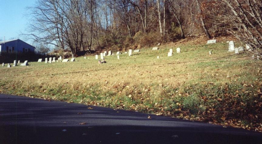
Auburn Cemetery - Mill Street

|
|
Update -
In 2019, a young Auburn-resident named Sarah Bretzius approached the Auburn Area Historical Society with a worthwhile project. Her intent is to "beautify and restore" the Auburn Cemetery located adjacent to Mill Street. Some graves were unmarked and their interments might never be correctly identified. Other grave markers were never engraved, are badly worn to the point of being illegible, or are so badly encrusted with growth their inscriptions cannot be read. Still other grave markers are leaning with some having already toppled. Of those markers that had previously toppled, some are becoming so overgrown with grass and covered with dirt that they can no longer be seen. Still other grave markers are broken in two or more pieces. This young woman's intent was to use professionally approved cleansers especially designed for grave markers to clean dirty or encrusted grave markers; to straighten all crooked or leaning grave markers; to erect grave markers that had previously toppled; to repair grave markers that are broken; to locate grave markers that might be already covered with dirt and grass; and to attempt to identify individual unmarked interments. The Auburn Area Historical Society not only supported this young woman's project on the basis that she has voluntarily undertaken a project which helps protect and preserve an important Auburn historic site; but also because this worthwhile cause will restore some decency and dignity to those grave sites containing many of Auburn's earliest inhabitants. As a result of the A.A.H.S. support, Chairperson Todd Graybill recommended that prior to initiating this project, a final highly comprehensive search should be conducted in an effort to determine legal ownership of the cemetery. An on-line search of references to the cemetery provided no proof of ownership. However, an on-line search of the Schuylkill County Courthouse Parcel Locater Map contained record of the owner's name. According to the Parcel Locater, the Auburn Cemetery's owner is: the Auburn Cemetery. Since the cemetery obviously cannot own itself, an online search was done of the Schuylkill County Courthouse CAMA card records for tax purposes. This document indicated both an owner and an owner's mailing address. According to the CAMA card, the Auburn Cemetery's owner is: the Auburn Cemetery again! The owner's mailing address was simply listed as: "General Delivery", Auburn, PA 17922. In other words, correspondence would be taken to the cemetery site and left with those individuals who were already interred. However, these two documents did provide a legitimate clue to the true ownership of the cemetery parcel. A reference was made on both documents to the deed for this plot of ground, to be located in the Schuylkill County Courthouse, Office of Deeds, Deed Book 0227, Page 0222. Todd Graybill was given a copy of the most recent deed for the cemetery property that was legally filed with the Schuylkill County Courthouse. The deed was almost 175 years old at that time, dating from 1845. The small, tight cursive writing was hard to read, and Todd has exactingly transcribed the deed to include all misspellings and archaic word usage. The deed provides a clear record of ownership prior to and including its current owner. Prior to any cemetery or church being located upon, or even owning, the land, at least one previous interment had occurred within this parcel. In 1823, a Johannes Staudt was interred on the property. The reason for his interment at this location is unknown. He may have been a family member, friend or neighbor of whomever owned the property in 1823. Prior to 1836, the property including the parcel now known as the Auburn Cemetery was divided amongst two property owners, an Abraham Faust and a Jacob Seigfried. On February 11th, 1836, a Dewald (or Dewalt) Faust was deeded a portion of the parcel containing what is now known as the Auburn Cemetery from Abraham Faust. On that same day, Dewald was deeded a portion of the parcel containing the remainder of the property now known as the Auburn Cemetery from Jacob Seigfried. Dewald Faust was now the owner of the parcel in question. Prior to 1845, various local residents pursued their religious convictions by worshiping in private homes, and then eventually utilizing an old pottery shop/shed for a place of worship. Historical records have not identified the location of the old pottery shop. In 1843, some of the residents officially formed a congregation to pursue their specific theology. The congregation called itself "the Church of God". In 1845, four significant developments occurred. First, other congregants who had somewhat different religious beliefs began their own congregations. One of the congregations formed into the Auburn Reformed Church, and the other formed into the St. John's Lutheran Evangelical Church. Also in 1845, Dewald Faust and his wife Molly deeded the parcel of land containing what is now known as the Auburn Cemetery to the congregation calling itself the "Church of God" and was represented by two of the congregations trustees, a John W. Deibert and an Isaac Hoffmeister. The deed specified that the land must be used for a "place of worship" and/or a burial ground by the congregation. The ownership of the land in question was clearly transferred from private ownership by the Fausts to ownership by the Church of God congregation. Finally in 1845, a fund-raising drive involving area residents from various congregations occurred in an effort to raise money to build a house of worship. The largest single donation was $100. The most modest donation was 12 1/2 cents. The congregation known as the "Church of God" was the only congregation at the time to own a parcel of land, so they offered a portion of that parcel upon which to build a joint house of worship. Construction began in late 1845 (and concluded in 1846) of Auburn's first house of worship, commonly referred to as "the meeting house". The stone structure was built in the northeast quadrant of the parcel of land known now as the Auburn Cemetery. The structure's size is estimated to have been between 20' x 20' to 20' x 30' maximum. While the parcel of land clearly remained within the ownership of the Auburn Church of God, the meeting house's ownership is not stated but may have been considered owned by all of the congregations using the structure. In 1847, the first known official interment occurred within what was now considered a burial ground. The first individual to have been officially interred within the cemetery was Auburn-resident William Hay. William Hay was a historically significant individual. Arriving from Scotland, he worked as a "lock keeper" or "lock tender" at one of the closest locks of the Schuylkill Navigation System (commonly but erroneously referred to as the "Schuylkill Canal"). Prior to the growing settlement being officially named "Auburn", people referred to the geographic area that would eventually grow into Auburn as "Scotchman's Lock" in deference to William Hay. On William's grave marker is the inscription "William Hay...the old Scotchman". By 1857, the congregations of the Auburn Reformed Church, and the St. John's Lutheran Evangelical Church, decided they wanted their own house of worship. Those individuals began construction of the structure that would eventually become the present St. John's Church located north of Pearson Street between Second and Third Street in Auburn. This building was officially dedicated in 1859. Both congregations chose to relocate to this structure and discontinued their use of the community meeting house. At this time, the only congregation left still utilizing the meeting house appears to have been the owners of the property on which it was located, the congregation known as the Church of God. By 1868, the Church of God congregation had outgrown the tiny meeting house and began construction on a new house of worship located north of Market Street (between Second and Third Streets). The congregation relocated to this location and the original official house of worship in Auburn, the meeting house, was abandoned. With the relocation of the congregation, legal ownership of the cemetery parcel transferred with them to the new structure, and the congregation became known as "The Auburn Church of God". By 1872 the structure was deteriorating rapidly and eventually fell into ruin. The structure was razed for reasons of safety but a portion of the stone foundation is still evident in the northeast quadrant of the cemetery. Original Church of God trustee John W. Deibert's fate is unknown. A search of historic records was unproductive. The Church of God trustee Isaac Hoffmeister apparently remained with the congregation which became the Auburn Church of God. In 1899, Isaac was interred in the "new" Church of God Cemetery located north of Pearson Street between Second and Third Streets of Auburn. After a review of all of the historic and legal documents available, Todd Graybill did not want to presume actual legal precedent of ownership, so he requested that a solicitor who does "pro bono" work for the Auburn Area Historical Society review the documentation and give his legal opinion of ownership. Upon review, the solicitor concluded that the ownership originally belonged to the Church of God, and that the congregation known as the Auburn Church of God currently has ownership of the cemetery. Todd then notified the Pastor and his wife of the Auburn Church of God of this development, as well as explained the restoration project. The Pastor and his wife (Kerry and Tina Duke) graciously expressed their appreciation for bringing this previously unknown ownership to their attention, and gave their approval and blessing to proceed with the gravestone restoration project. As of February, 2019, ownership of the Auburn Cemetery has been restored to the Auburn Church of God. A letter explaining these developments was sent to the Cemetery Fund Committee operating from St. John's Church to determine whether their intent is to continue gathering funds and using those funds to pay for basic maintenance or, if they waive any and all future responsibility, and would redirect any contributions for this cemetery's upkeep to the rightful owner - the Auburn Church of God. The St. John's Church's Cemetery Fund Committee never responded to the request, but their subsequent decision clearly expressed their intent. Regrettably, once legal ownership was definitely established, numerous "charitable" organizations to include the Auburn Game and Fish Association, the Auburn VFW and the St. John's Church elected to discontinue their financial support of maintaining this historic site. |
**************************************************************
|
Mystery #013 - "The Chiseled Church"
Auburn seems to have its fair share of mysterious references to unidentified or unidentifiable churches and/or other places of worship. In Auburn's oldest known public cemetery lies a joint grave marker circa 1860 for the Vanderheyden children. The cemetery was first utilized in the 1820s and was later affiliated with the original Auburn "Church of God". A small "Meeting House" was built circa 1845 within the cemetery grounds and was considered the first formal house of worship in the immediate area surrounding Auburn. The "new" church was built in 1857 for the Lutheran and U.C.C. congregation to share. By 1860, when this grave marker was assumed to have been engraved, someone had chiseled the name "Gabriel Miller" and "Sun' Mountain Church" on the bottom of the stone. Neither "Gabriel Miller" nor a place of worship referred by the name "Sun' Mountain Church" (or "Sunday Mountain Church", "Sunrise Mountain Church", "Sunshine Mountain Church" or "Sunset Mountain Church") is presently known to the historians of the Auburn area. It is uncertain whether the word "Sun" stands "alone" or whether their is an apostrophe mark immediately following the letter "n" in the word "Sun". According to website contributor Donna Miller, there was a "Gabriel Miller" who was born on December 16, 1816 in Schuylkill County and died on June 5, 1886 in Schuylkill Haven. He was married to a Susanna Stahl Miller; and they had at least seven children and possibly as many as eighteen children. Whether he is the individual whose name is carved in the grave marker is uncertain. Gabriel is buried in the Jerusalem Cemetery, Schuylkill Haven, Schuylkill County, PA. Sunday is also a local surname in the Auburn area dating back into the 1700's and its original format of "Sontag". If you have any knowledge of a local geological feature being referred to as "Sun/Sunrise/Sunshine/Sunset/Sunday/Sontag" Mountain, let us know. If you have any information regarding the "chiseled church" or a "Gabriel Miller", please use our Visitor Input button to share your insights with us. |
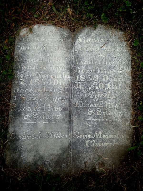
This dual grave marker for the Vanderheyden children contains two mysterious engravings chiseled near the bottom of the stone. The name "Gabriel Miller" and "Sun' Mountain Church" are presently unknown in Auburn's history.
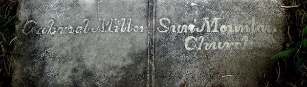
Enhanced close-up of chiseled engraving
|
|
Update -
Our sincerest thanks goes to AAHS website contributor Donna Miller for having submitted the following information that might solve the mystery of the "Sun" Mountain Church. Donna wrote: "In regard to Sun Mountain Church, I am in the Reber family and do research my genealogy. In searching I found that my 4th Great Grandfather George Reber & the Henny family co-owned a farm on Sum Mountain which is Summer Hill Road (still owned by the Reber family), right near the Summer Hill Churches. I have information showing that they believe the original Summer Hill Church was on the opposite side of the current churches. It also tells me exactly where this church sat and if you go into the cemetery there are tombstones all around, but not on that spot. So this could be the church you are referring to." Considering the age of the stone and the possible damaged spot after what had appeared to be the word "Sun", it's possible this word originally read "Sum." instead...making it feasible that the stone referred to the original church located on Summer Hill Road. |
**************************************************************
|
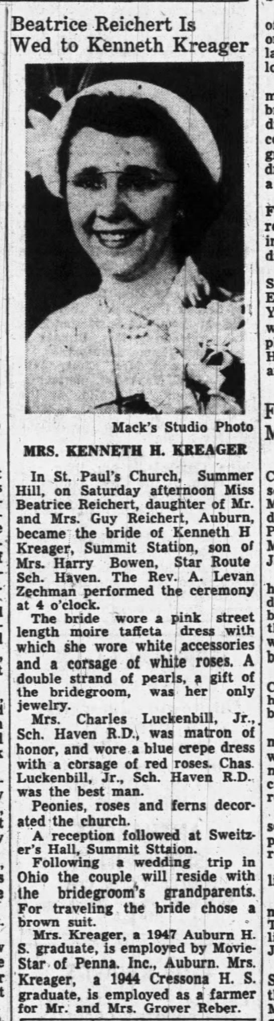
Mystery #014 - "The Movie Star Mystery"
To the best of our knowledge, Ms. Beatrice Reichert Kreager wasn't considered a "Movie Star" by our current perceptions of the term. She was born on September 20, 1928, the daughter of Guy K. Reichert and Ellen Sarah Heim Reichert of Auburn, Schuylkill County, PA. She was a sister of a stillborn girl who died due to a "premature birth" according to the death certificate. Beatrice was a simple Auburn girl who married a boy from Summit Station, Schuylkill County, PA. Their wedding announcement was a standard format, telling of relationships and matrimonial wear. She is a mother to Arlene Kreager, Linda Kreager and Robert D. Kreager. A graduate of Auburn High School, she worked as a homemaker and alongside her husband for many years at the family dairy farm they owned together. Beatrice died on March 17, 2011 in Schuylkill Haven, Schuylkill County, PA and is interred at St. Paul's Cemetery, South Manheim Township, Schuylkill County, PA. What is curious, even most interesting perhaps, is that the article states that Mrs. Kreager is employed by "Movie-Star of Pennsylvania, Inc. - Auburn". This corporation is one with which we have no familiarity. If you have any information of the glamorous if little known employer called "Movie-Star of Pennsylvania, Inc.", let us know by inputting your knowledge to the "Visitor Input" button featured on this webpage! Update -
An Internet website, www.govinfo.gov, has a listing circa March, 1950 as "Movie-Star of Pennsylvania, Inc." having been located at the corner of Front and Washington Streets in Auburn, PA. The mention is found in the "Federal Register" on page 1255 of that website. The only known building on the site mentioned would have been what was originally the Artistic Knitting Mill. This structure caught fire in the 1990s and was subsequently razed for safety reasons. Update -
Our sincerest thanks to AAHS website viewer Marc Pavlesich for helping solve this mystery! Thanks to diligent viewers and participants like him, the AAHS website is able to "close" some of these "Mystery of History" cases. Marc sent the following excerpts in an email to our website: "In regards to the 0014 Movie Star Mystery... Perhaps the young woman worked for Movie-Star Inc which was a lingerie and sleepwear company based out of NYC. She could have done "homework" which was piecework done for the company from home... Maybe? Here is something from Wikipedia... Movie Star Inc. is a New York City-based manufacture, marketer, and seller of lingerie, sleepwear and other types of clothing. Organized in 1935, and then formerly known as Sandmark Stardust Inc. in 1992. It was acquired by Frederick's of Hollywood in 2006, who sold the company to Dolce Vita Intimates in 2010." |
"Movie-Star of Pennsylvania"?

Vintage non-professional post card circa 1920s depicting the "Auburn Manufacturing Company Knitting Mills"
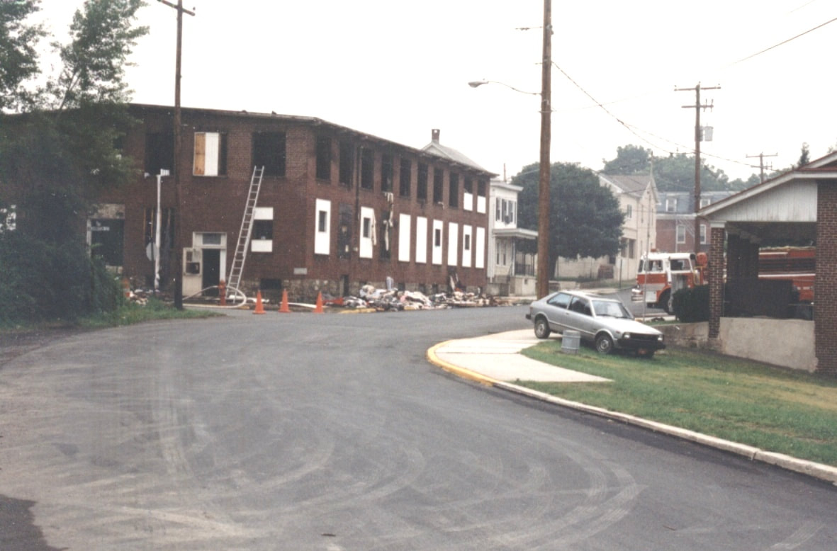
The former Auburn Manufacturing Company building, home of the business "Movie Star of Pennsylvania, Inc." at one point, suffering from a catastrophic fire in the 1990s.
The lot where the prior "Movie Star of Pennsylvania, Inc." building once stood. The structure was demolished and razed after having been destroyed by a devastating fire.
|
**************************************************************
|
Mystery #016 - "The Grave-digging Hermit"
The mystery of the grave-digging hermit involves an as-of-yet unsubstantiated belief at this point that, at one time in Auburn's past, a somewhat reclusive fellow lived in a small shack located in the woods just north of the Auburrn Church of God cemetery and the St. John's Lutheran Church cemetery, both of which are located adjacent to Cemetery Road, Auburn, Schuylkill County, Pennsylvania. This individual is believed to have supplemented his income by hand-digging graves at one or both of these cemeteries, possibly as late as the 1950s. Currently, his identity and his employment are both unconfirmed. At least one small shack was previously located in this general area (pictured on right). Whether or not this structure was ever inhabited is uncertain. However, Brian Bohr, a Liftetime Member of the AAHS, recalls playing inside of a small dilipidated shack in this general area many years ago as a young boy. He stated that the shack in which he played showed signs of once having been occupied. Additionally, an enlargement of a portion of the 1875 DeBeers Atlas map of Auburn, Schuylkill County, PA depicts a structure situated just north of the Auburn Church of God cemetery in the top left corner of the map. The structure indicates it was owned by a "J. Comiskey". As a vacant outbuilding would not normally be represented by an owner's name on this map, the presumption would be that "J. Comiskey" once occupied that structure. Whether or not this structure depicted on the map is the same structure referred to in either passage written above is unknown. What is certain is that if a presumed adult named "J. Comiskey" occupied that structure in 1875, then he would almost certainly have not still been digging graves over 75 years later. The website findagrave.com has no listing for a "J. Comiskey" of this era having been interred anywhere within Schuylkill County. However, it does list a "John Comiskey", who was born in 1830 and died in 1918, who was interred in Reading, Berks County, PA. He would have been approximately 45 years old when the 1875 DeBeers Atlas was published...a reasonable age for a grave-digger. A point of interest is that his step-daughter, Agnes Kissick, married John Morrison of Auburn, Schuylkill County, PA, so it's possible his family was situated in or near Auburn at one point in their lives. Whether this is the same "J. Comiskey" that is featured on the 1875 Atlas map is uncertain. Do you know anything about "the Grave-digging Hermit?" If you have any further information on "J. Comiskey", or on any of the structures located in the woods just north of the two cemeteries, or any information on the identity of the person who occupied a shack in that area in the 1950s, please use the "Visitors Input" button below to share your information and/or pictures with us! Update -
Thanks to the investigative work of AAHS Lifetime Member Brian Bohr, this mystery of history may have been solved. When Brian spoke with long-time Auburn residents (and Lifetime Members of the AAHS) Gil "Sonny" Steffy and Nancy Steffy, he was informed that at least two individuals separately occupied a structure located in the woods north of the cemetery. The earlier one was a fellow known as "Sandy" Long. The more recent occupant was a fellow named Samuel Kramer, who was believed to have occupied the shack into the 1960s. A search of the website findagrave.com only listed a single individual interred within all of Pennsylvania with a surname of Long and a nickname of "Sandy". The individual listed on that website was Nathan "Sandy" Long who was born 08/08/1872 in Donaldson, Schuylkill County, Pennsylvania. He married Mary E. Harris Long and they had at least five children: Annie Long, Arthur Anthony Long, Mrs. John Long Foy, Theresa Long and Viola M. Long Bloch Bixler. However, there are several conflicts in believing this individual was the same "Sandy" Long identified by the Steffys. First, his obituary stated he lived in Rausch Creek for the last 53 years of his life, which would have been from approximately 1913 until 1966...therefore, he could not have permanently inhabited the shack in question during the time span that the Steffys would have recalled. Second, Nathan's wife died in 1934 leaving him with five children, one of which was a twenty year old adult female, one a fifteen year old son, one a fourteen year old daughter, and two children whose ages were not able to be determined based on the information available on the website. Assuming he may have stayed in his residence until his teenage daughter became of age to be independent (16 years old or older), that would place him in the year of 1936 at that time. His obituary did mention he worked "several other jobs" from 1930-1946...but supposedly this would have been within the time span he was permanently residing in Rausch Creek. A slightly possible explanation might be that he worked as a grave digger for one or both churches whose cemeteries are located near the shack (Auburn Church of God and St. John's Church) and that he occasionally stayed overnight within the shack while he was working, but he did not appear to permanently reside there (a distance of approximately 24 miles from Rausch Gap to Auburn). As a result, it is uncertain that Nathan "Sandy" Long is the same "Sandy" Long as was recalled by the Steffys. The second individual, Samuel Kramer, was far easier to tentatively positively identify using the website findagrave.com. The website has a listing for a Samuel Kramer who was born on 08/29/1886 in Auburn, Schuylkill County, Pennsylvania. He was the son of George Kramer and Elizabeth Shoener Kramer. He was a brother of Alice Kramer Fisher, Amanda Kramer Fisher, Harry Kramer, John Elmer Kramer, Katie Kramer Faust and Pheope (Pheobe?) Kramer Wenerich Wildemuth (Wildermuth - her last name was misspelled on her grave marker and quite possibly her first name as well). Samuel married Rebecca Strausser Kramer in 1908. They had two children: An Abraham L. Kramer who was born in 1912 and died by 1938 at the approximate age of 26, and Wilbert Clifford Kramer who was born on May 20, 1910 and died on August 20, 1910 at the age of 3 months. Samuel's wife, Rebecca, died in May of 1941, leaving him a widower with no surviving children at the age of 54. Samuel could have possibly moved into the shack located north of the cemeteries at this time (presuming he did not already reside there with his small family). At the age of 54, he could feasibly have worked as a grave digger from the 1940s into the 1960s if he was in good health; or possibly had just resided there until the 1960s (into his mid- to late-70s) before relocating to North Manheim Township, Schuylkill County, PA, where he died on 07/18/1967. This time-frame would have fit the period that the Steffys stated a Samuel Kramer resided in the shack. As a final point of interest, Samuel was interred within the Auburn Church of God...not too far from the shack he possibly inhabited. The likelihood of this being the same individual who inhabited the shack north of the Auburn Church of God cemetery seems to be a strong probability. A special thanks goes to Gil "Sonny" Steffy and Nancy Steffy who provided information to Brian Bohr that helped shed light upon the mystery of "The Grave-digging Hermit". ************************************************** Update - Thanks to long-time AAHS website visitor and contributor William "Bill" Shollenberger, we now have better insight into the life of Samuel Kramer. Bill states that his uncle Mason "Mace" Ramer knew Samuel personally and that "Mace" would talk to Samuel when he saw him in town. Bill states that if he was accompanying his uncle (as a child), then the two adults would converse in "Pennsylvania Dutch" which was a common practice of old-timers when children were nearby. Bill states that Samuel was very reclusive and that he only came into town to buy groceries...that Samuel preferred to be alone. Bill adds that Samuel did live in the shack in the woods north of the two cemeteries, along with his dogs. Bill confirmed that Samuel did definitely dig graves (by hand) for the two cemeteries. Bill recalls walking past Samuel's shack with other children on their way to play at the "spring hollow" north of there. He says that some of the other kids were afraid of Samuel, but that he never hurt anyone and kept to himself and his dogs. If Samuel was outside of the shack when they passed, he was frequently working in his small garden or repairing the shack. A special thanks goes to Bill for sharing these facts with the website and giving its visitors a special insight into the life of Samuel Kramer. |
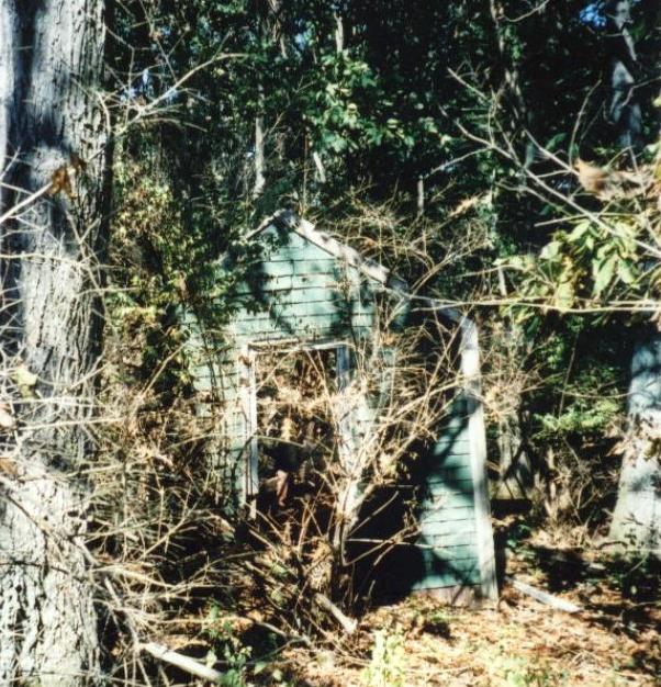
Remnants of a small shack once located in the woods just north of the Auburn Church of God cemetery.

An enlargement of a portion of the 1875 DeBeers Atlas map of Auburn, Schuylkill County, PA which depicts a structure situated just north of the Auburn Church of God cemetery in the top left corner of the map. The structure indicates it was owned by a "J. Comiskey".
|
